This is the first set of routes in an all new concept I’ve come up with for those on all budgets wishing to get the absolute best riding experience without the many hours of research it takes to plan a trip or the the expense of a tour guide.
What is available?
ROUTES |
APPAREL |
STICKERS |
| REQUEST ROUTES AT denis.smyth@roadtrooper.com – Price: €30.00 |
VISIT STORE » – Apparel from €17.50 |
VISIT STORE » – Stickers from €2.99 |
 |
 |
 |
.
As a motorcycle tour guide living in Killarney these are my routes that, based on customer feedback have been fine tuned for the optimal way to see and ride the very best roads and sights in the region. The zip file will also contain a separate POI folder with hotels, B&B’s, hostels, campsites, cafes, restaurants, scenic/photo stops, motorcycle mechanics, basically everything you need in over 200 poi’s. For many, few will ever find many of the hidden POI’s in this download. I’ve done all the research and legwork before riding these routes many many times over a 5 year period.
.
Contents of .ZIP
- 1 x Folder containing 6 routes in .GPX format to be opened in Home, Basecamp, Type or for transfer to MyRouteApp for IOS/Android
- 1 x Folder containing 6 routes in .KML format to be opened in Google Earth
- 1 x Folder containing POI’s in both .GPX and >KML format. Each day route is shaped using poi’s, however there are far too many POI’s to put into the routes themselves. This folder will contain all the potential POI’s you could possibly need (E.G bars, restaurants, beaches, beauty spots, mountain passes, museums, bike shops/mechanics, hotels, campsites etc. These will allow you to alter my routes to help cater for your own personal interests along or off the routes.
The Routes
- Killarney – Beara Peninsula 230km
- Killarney – Mizen Head 245km
- Killarney – Dingle Peninsula 190km
- Killarney – North ROK & Highlands 230km (Note: ROK=Ring of Kerry)
- Killarney – South ROK & Highlands 200km (Boreens)
- Killarney – Sheep’s Head Peninsula 240km (Boreens)
The POI files contain 230 POI’s I use in Killarney/West Kerry/Cork including but not limited to:
- Camping sites – 18
- Cafe’s/Restaurants – 37
- Route Fuel Stations – 21
- B&B/Hotels/Hostels – 43
- Motorcycle Rental – 2
- Motorcycle Mechanics – 3
- Unmissable Mountain Passes – 18
- Photos Stops – 72

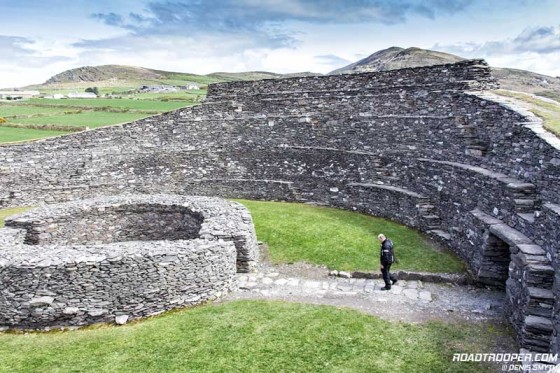
Ride the traditional Ring of Kerry route like most folks and you’ll miss stunning POI’s like this Ancient Irish Ring Fort in Kerry, some dating back to 1000 BC. It’s places like this you’ll find along my routes.
.
How to get the zip file
Until I can get a proper website digital download system in place we’ll have to do this the old fashioned way using email.
.
Price
Email me what you feel the files are worth to you, the suggested value is €30, I think it’s worth at least that and for small groups at least it’s cheaper than hiring a personal guide. First contact me at denis.smyth@roadtrooper.com with a fair offer, once I have your email address I can send you a PayPal payment request, you don’t need a PayPal account to use the service. Once that’s done I’ll email you the files you need and remain available for any questions or help you need with them. If you wish to pay more than the suggested amount that’s great, the proceeds of this will go towards the redevelopment of the RoadTrooper website which badly needs updating.
.
Description & Info:
Why do I call them Self Guided DIY Tours? Basically these routes are the cheapest possible way for most of my brother and sister motorcyclists to get a pre planned guided tour bypassing many hours of research and saving costs on booking fees and a physical guide. With this option all you have to do is 4 simple things.
- Download and install the route to Garmin, TomTom, Tyre or MyRouteplanner for IOS/Android.
- Choose and book your own accommodation or campsite in the Killarney area and edit the route to include your accommodation/poi as the start/end point.
- Get to Killarney on your own bike. If you need to rent a motorcycle in Killarney let me know and I’ll organise it with a reduction.
- Ride the route via poi’s with your Satnav or Smartphone as a guide.
Each downloadable for this region set (Ireland South West) contains 6 routes based on the routes I designed for LemonRock Motorcycle Rentals and for my Guided Peninsula Day Tour routes which I’ve been leading from Killarney for the last few years. Over the last years since returning from Spain I’ve plowed these routes countless times, and based on customer feedback and my own intimate knowledge of the routes I’ve optimized them for the best possible experience. Each downloadable contains a number of folders containing 6 routes (garmin, tomtom & KML-Google Earth files), and a separate POI folder (garmin poi file, garmin POI Loader file, TomTom POI file and a Tyre POI file).

RoadTrooper’s Self Guided DIY Tours
.
Duration of Each Route
Each route takes between 6-8 hours to complete. Boreens are included in routes 5 and 6, most notably at the Priests Leap Pass, Gap of Dunloe and Black Valley, these are narrow, one track, poorly surfaced roads often with grass growing along the center. Extra care should be taken in these locations, especially in poor weather and/or riding with pillion passengers. KML files are also supplied, these can be opened in Google Earth. I recommend to use Google Earth Street View to view the roads, especially the boreens to make sure you are happy to navigate them. Note: During very bad weather, strong winds, low clouds or any weather warning the Priests Leap Pass is best avoided completely. Getting help on these remote mountain boreens can be difficult and may require a long wait so please take both your safety and your fellow riders safety seriously and ride with caution.
Route Notes
I have chosen Killarney as the base “start and end point” for these routes for a number of reasons. Firstly due to its central location giving excellent access to the best roads and destinations themselves. From this location and using these routes you will cover the most ground possible, there is no better way to see and explore the region. Secondly Killarney is without question the most ideal town for finding suitable accommodation be it a campsite or 5 star luxury hotel. The town itself also has enough pubs, restaurants and entertainment to keep even the wildest fully occupied a solid week. Killarney is a mid sized town of 14,000 that professionally and safely accommodates the 1.1 million tourists that visit it each year and has a total bed (Hotel/B&B/Hostel) capacity of 10,000.
Killarney is also easily accessible by train, bus, airplane (Kerry Airport) and just a day’s ride from the main ferry ports at Cork, Rosslare, and Dublin. Belfast port is also easily doable within a day, approx 6-7 hours. For those arriving without their own transport cars may be hired at Kerry Airport and motorcycles can be hired with a RoadTrooper discount at LemonRock Motorcycle Rental at the Brehon Hotel in Killarney. If renting a motorcycle at LemonRock take note that if you choose to use one of their SatNavs it will come pre-loaded with similar routes but with less poi options.
- Each day route begins at the last fuel station exiting Killarney “trip start”, and ends at the first fuel station entering Killarney “trip end”.
- To edit the start/end points to include your chosen accommodation simply add the location to the start and end points in Garmin’s BaseCamp, TomTom or Tyre software.
- Each route includes all the best twisty or scenic roads, fuel stops, cafe’s and Photo/POI’s, all are good if not outstanding if you choose to stop at them.
- Assuming you stop to take photos, lunch, coffee etc and keep to the speed limits each route should take between 6-8 hours. In July/August this may take longer with traffic.
- Most of the POI’s, fuel stations etc are waypoints within the routes, but not all. POI’s outside these day routes are included in the specific POI files, these include hotels, campsites, restaurants and really good traditional Irish bars where you’ll find music, food, Guinness, whiskey, possibly me and of course the Irish craic. For Garmin it’s the .gpi file, for TomTom it’s the .ov2 file. To install the POI’s for Garmin use either BaseCamp or the Garmin POI loader. For TomTom you can use either TomTom MyDriveConnect or Tyre.
- The Garmin routes (.gdb and .gpx) supplied were created using BaseCamp version 4.6.2, all versions of BaseCamp should transfer these files to your SatNav.
- The TomTom .itn (itinerary) files where created in Tyre, to transfer these to your TomTom SatNav simply connect your SatNav to your PC and transfer using MyDriveConnect or Tyre.
If your TomTom is a basic model it may not support TomTom .itn (itinerary) files in which case you can still load the POI .ov2 file in Tyre and transfer all the POI’s to your SatNav and recreate the route from there. Depending on your TomTom SatNav model you may also transfer the route as an active route within Tyre. - Garmin users only. Many of the POI’s and Waypoints have extra information in the notes section.
.
.
Mapping Software – How to use the files
Garmin:
BaseCamp is free to install but you need to pay for the maps, these however come with your Garmin SatNav so you should be good to go if you have created an account and registered your
Garmin SatNav on the Garmin website. The Garmin POI Loader is a separate download and is also free.
Download BaseCamp Mapping Software: https://www8.garmin.com/support/download_details.jsp?id=4435
Download Garmin POI Loader: https://www8.garmin.com/support/download_details.jsp?id=927
TomTom:
Tyre Basic is free and works equally well with both Garmin and TomTom SatNavs and integrates really well with Google Maps and Google Earth and many gpx file formats. In many ways it’s far better and simpler than both the Garmin and TomTom solutions. I highly recommend it.
Tyre:
Tyre is a route mapping software which uses Google Maps to plot the routes. Tyre works equally well with Garmin, TomTom and other SatNav file formats as well as Google Map/Earth KML and KMZ files. The basic version is free to use. It also integrates with MyRouteApp and Sygic so you can use the .gps/.gdb/.itn etc files in Tyre for free and transfer them via MyRouteApp to your IOS or Android phone easily enough.
Download Tyre: http://www.tyretotravel.com/
Download MyRoute-app: https://www.myrouteapp.com/en#homevideo
.

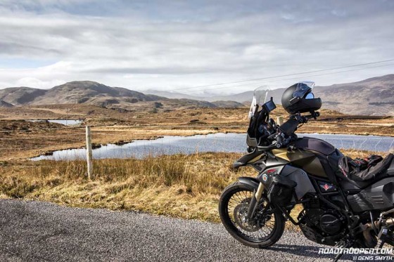
One of the many back roads near Killarney that only the locals use. I’ll often use this road to bypass the many coaches and heavy tourist traffic in summer and as part of my guided day trips.
.
Accommodation
Take note that Killarney is a small town that sees up to 1.1 million tourists every year in the town itself, and over 4 million in the overall region. I highly recommend booking well before your arrival, for high season at least 6 months in advance. We get many coach tour companies here, these guys bulk book rooms 1 year or more in advance. Many hotels do not put all their available rooms on booking.com etc. So if you see a hotel/B&B booked out online it’s still worth calling them direct, also you may well get a room cheaper buy doing so, i.e. bypassing the online agent booking fees.


